TYPHOON VONGFONG (AMBO) UPDATE NO. 09Issued at: 7:00 AM PhT (23:00 GMT) Thursday, 14 May 2020
Next update: 1:00 PM PhT (05:00 GMT) Thursday, 14 May 2020 |
|
|---|---|
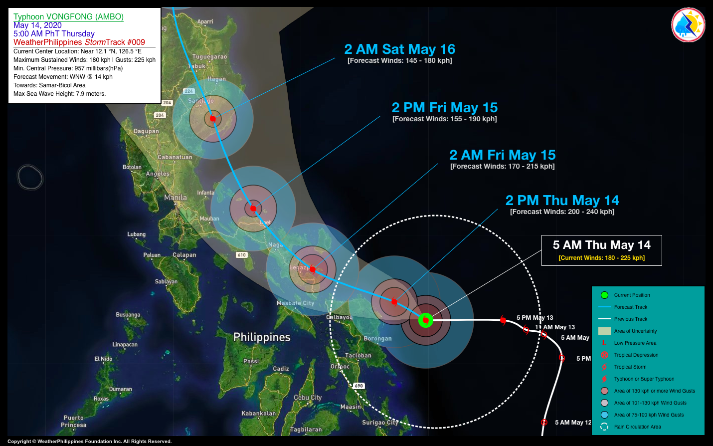
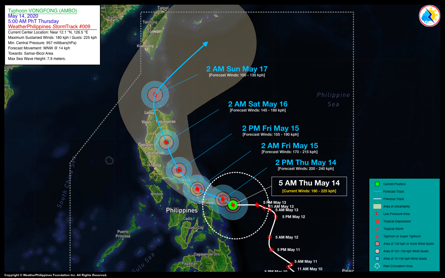
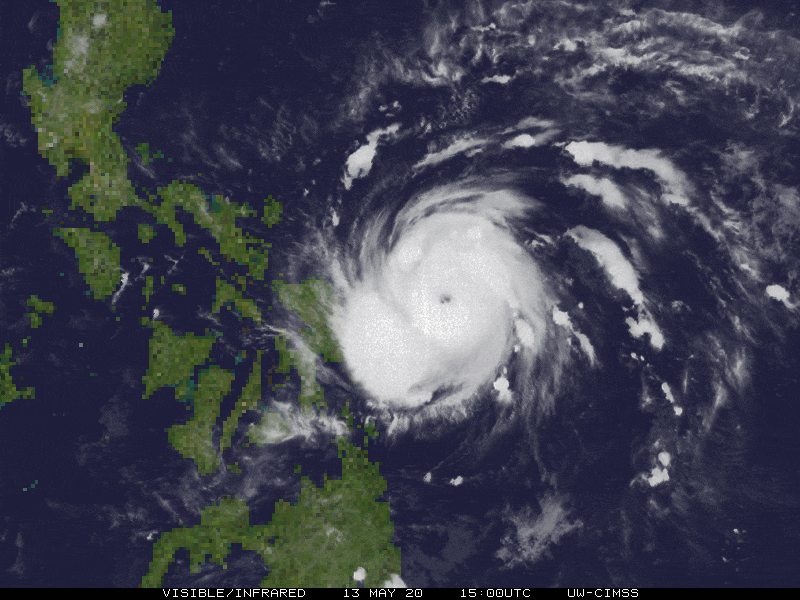
| Current Status and Outlook | VONGFONG [AMBO] is now a Powerful Category 3 Typhoon with winds of 180 km/hr (Dvorak 10-min average) as it march closer to Northern Samar and Eastern Bicol Region. This typhoon is similar in strength of Typhoon Kammuri (Tisoy) of December 02-03, 2019. Its Outer Rainband is now beginning to spread across Samar and Leyte Provinces.
24-hr Outlook: TY VONGFONG (AMBO) is forecast to continue intensifying while moving west-northwestward with a forward speed of 14 km/hr, as it approaches the coastal areas of Northern Samar by this afternoon, and will make landfall along Eastern Albay by early tomorrow morning (Fri, May 15). The Western Trough of TY VONGFONG (AMBO) will continue to bring scattered to occasional rain showers and thunderstorms across Eastern Mindanao, Eastern Visayas, and Bicol Region today. |
| Where is VONGFONG (AMBO)? | As of 5:00 AM PhT today, May 14…2100 GMT. The ragged eye was located over the southwestern part of the Central Philippine Sea (near 12.1°N 126.5°E), about 205 km east of Catarman, Northern Samar or 324 km east-southeast of Legazpi City, Albay. |
| How strong is it? | Maximum Sustained Winds (10-min avg): 180 kph near the center…Gustiness: 225 kph. |
| Past Movement (06 hrs) | West @ 16 kph, towards Samar-Bicol Area. |
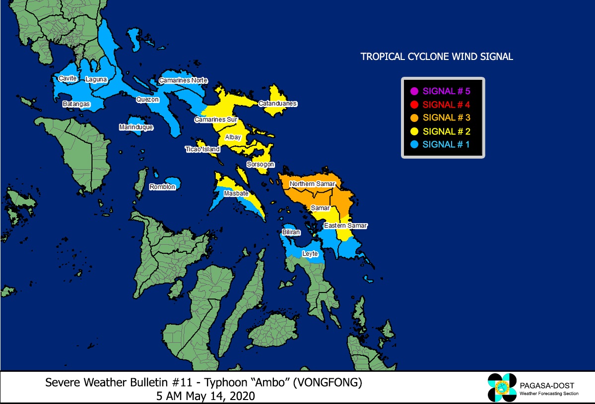
| Potential Philippine Landfall Area(s) | :: Over Eastern Albay (along Rapu-Rapu-Batan-Cagraray Islands Area, Albay), between 3 to 4 AM local time on Friday Early Morning (May 15) – with High Strike Probability of 85-90%. |
| What Philippine areas will be directly affected? | Heavy to Extreme Rains (50 mm to more than 100 mm expected):
>> Bicol Region, Northern & Eastern Samar – beginning today through Friday (May 14-15). Damaging Winds (gusts of more than 100 km/hr expected): >> Northern Samar, Sorsogon, Albay, Southern Catanduanes – beginning Thursday Evening through Early Friday Morning (May 14-15). |
| Potential Storm Surge/Coastal Flooding Areas+ | :: Along the coastal and beachfront areas of Bicol Region, Samar Provinces, Aurora, and Quezon – beginning today through Friday (May 14-15).
+Waves of 1 to 3 meters in height is expected in storm surge-prone areas, particularly in coastal areas on where the Tropical Cyclone is headed. Kindly visit the PAGASA Storm Surge Updates for more details. |
| 3-Day Forecast Outlook Summary** | FRIDAY EARLY MORNING: Makes landfall over Eastern Albay (near Tabaco City) as it weakens into a Category 2 Typhoon while heading WNW to NW-ward…about 34 km ENE of Legazpi City, Albay [2AM May 15: 13.2°N 124.0°E @ 170kph]. Confidence Level: HIGH.
SATURDAY EARLY MORNING: In the vicinity of Quirino Province…weakens into a Category 1 Typhoon as it moves NNW-ward across Isabela and Cagayan…about 43 km NW of Casiguran, Aurora [2AM May 16: 16.4°N 121.8°E @ 145kph]. Confidence Level: MEDIUM. SUNDAY EARLY MORNING: Weakens into a Severe Tropical Storm (STS) as it emerges over the Balintang Channel…starts to recurve towards the NE…about 57 km WNW of Calayan Island, Cagayan [2AM May 17: 19.6°N 121.0°E @ 100kph]. Confidence Level: LOW. **Important Note: Please be reminded that the Forecast Outlook changes every 6 hours, and the Day 2 and 3 Forecast Track have an average error of 100 and 250 km respectively… while the wind speed forecast error, averages 35 km/hr per day. Therefore, a turn to the left or right of its future track and changes in its wind speed must be anticipated from time to time. |
| Other Storm Info | > 24 hr. Rain Accumulation (across its circulation): 25 to 450 mm [Light to Extreme]
> Minimum Central Pressure: 957 millibars (hPa) > Size of Circulation [Convective Cloud-Based, in diameter]: 515 km (Small) > Area of Damaging Winds (100 kph or more wind gusts): 60 km from the center. |
| Additional Information | Time/Date: 5:00 AM PhT Thu May 14, 2020 Location of Center/Eye: near 12.1°N Lat 126.5°E Lon Distance 1: 150 km NE of Guiuan, Eastern Samar Distance 2: 128 km ENE of Borongan City, Eastern Samar Distance 3: 300 km ESE of Virac, Catanduanes Distance 4: 395 km ESE of Naga City, Camarines Sur Distance 5: 650 km ESE of Metro Manila 24 hr. Forecast Coordinates (Class): 13.2°N 124.0°E (TY) 48 hr. Forecast Coordinates (Class): 16.4°N 121.8°E (TY) 72 hr. Forecast Coordinates (Class): 19.6°N 121.0°E (STS) |
| Information based on data collected by WeatherPhilippines Foundation, Inc. shall not be taken as official data. Weather information broadcasted and distributed by PAGASA remains as official data. WeatherPhilippines shall not be responsible for the private use and reliance of its weather information. | |